Two Not-so Off the Grid Explorations
Big Bend National Park and Grand Canyon National Park
June 12,2010 for The Grand Canyon Trek
November 5-8, 2015, and October 19-23, 2016, for my forays into Big Bend
I decided to document these two explorations into one document. I am doing this because while they were true explorations and discovering about the indigenous peoples of these areas, they weren’t truly off the beaten path. Thousands of people visit these national parks each year and walked the same trails I walked. Even though the beauty of the parks is breathtaking, little is left to truly explore or learn about the indigenous peoples that once made these places home.
Before I describe the trails, I walked and the things I did and saw, to be true to myself, I’ve included some of my research I did on the indigenous peoples of these areas.
The Grand Canyon

The Tribes of the Canyon
The Grand Canyon has been home to Indigenous peoples for thousands of years, with the area serving as a vital cultural and spiritual landscape for several tribes, including the Havasupai, Hopi, Hualapai, Navajo, Paiute, and Zuni. These tribes have deep connections to the canyon, viewing it as a sacred place and an integral part of their origin stories. The Havasupai, meaning “people of the blue-green waters,” have lived in and around the canyon for over 800 years, relying on the fertile land in the canyon’s depths for farming. The Hopi regard the Grand Canyon as the gateway to the underworld, with significant spiritual significance in their traditions. These tribes developed intricate knowledge of the canyon’s geography, ecology, and weather patterns, allowing them to thrive in its harsh environment.
My Journey
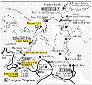
Inspired by my exploration of the Land of the Blue Green Waters, I wanted to see what everyone else had raved about. A true gem National Park, The Grand Canyon. Over the years that I lived in Arizona, I visited this park several times but my first visit in 2010, was the only one I truly did some exploring. I did a scouting trip in 2009 and hiked the Rim Trail, from the lodge at Grand Canyon Village to Hermits Rest, a 7-mile roundtrip. When I arrived the day before, I decided to scout out another trail that descended the canyon, the South Kaibab Trail. It got very cold and we abandoned the trek. That night I experienced over 5 leg cramps in both legs so the intended hike, Bright Angel to Plateau Point was scrapped for the Rim Trail hike, a much easier flat trail.

Map courtesy of HikingGuy
My real leg busting hike came on June 12, 2010. It was then I started down the Bright Angel Trail on my way down the canyon.
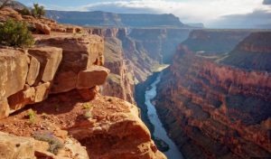
The Bright Angel Trail is one of the most famous and well-traveled trails in the Grand Canyon, starting from the South Rim down into the canyon’s depths. This trail has historical significance, as it follows a route originally used by the Havasupai people for centuries. The trail descends nearly 4,380 feet over approximately 9.5 miles to the Colorado River, passing through multiple ecosystems and has breathtaking views of the canyon’s layered rock formations. Along the way, there are rest houses and water stations, making it one of the more accessible trails. Bright Angel Trail is known for its challenging switchbacks, steep inclines, and the dramatic change in temperature as you descend. Despite its difficulty, the trail is probably the most hiked in the park. As I navigated the many switchbacks to first Indian Gardens the trail continues on its way across the Colorado River to Phantom Ranch campgrounds. Phantom Ranch is a lodge inside Grand Canyon National Park in Arizona. It sits at the bottom of Grand Canyon, on the east side of Bright Angel Creek, a little over half a mile north of the Creek’s confluence with the Colorado River.
Big Bend National Park

The Tribes of Big Bend
The indigenous people who inhabited the area now known as Big Bend National Park were primarily the Chisos and Jumano tribes, along with others such as the Apache and Comanche. These Native American groups thrived in the region for thousands of years, adapting to the harsh desert environment by practicing hunting, gathering, and later, some forms of agriculture. The Chisos people, for whom the Chisos Mountains in the park are named, were known for their deep spiritual connection to the land, which they considered sacred. The diverse landscape, including the Rio Grande, provided them with essential resources like water, food, and materials for shelter.
My Journeys
After experiencing The Grand Canyon many times, I had an exploration that was high on my bucket list. I moved back to Texas in 2011 from Arizona, and met an adventure writer, Pam LeBlanc. Pam led me to a hiking club that annually goes to Big Bend. I joined the club to team up with like-minded adventurers and went to Big Bend to explore the history, the culture, and the beauty of this great park. Because the park is so big, as everything else in Texas is, it took two trips there and I still have ye tot see and experience a great deal the park has to offer.
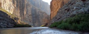
My first trip: 11/5-8/2015: I had in mind to hike the big 3 trails. Upon arriving, before unpacking, I made a beeline for the Window Trail. The view at the end of the trail is world famous. I lingered there taking in the view. On a later hike, I stood at the bottom of another trail and looked up get a view from below. The hike back to the campgrounds was harder than I thought. Maybe the adrenaline wore off. The next day, it was on to the second of the big three, The Lost Mine trail. This was a leg buster, long and steep. As I ascended, I ran into a lady that was having a tough time. I slowed my pace to support her by hiking with her and together we reached the top. This popular hike ascends to Casa Grande’s scenic east ridge and then climbs atop the ridge extending northwest from Crown Mountain West for superb views of the Chisos Mountains along with Juniper and Pine canyons. It has an elevation of 6,850-ft. at the top, and an elevation gain of 1,120-ft. with a 2.4-mile span. The last of the big three is Santa Elena Canyon. While it is a very easy hike, it starts at the Rio Grande river and provides incredible views of a canyon with side walls reaching to the sky. On this trip, I also took in Ernst Tinaja, Boquillas Canyon, and The Chimneys. The hike to the Chimneys is very flat drugged walk through the desert and was rather boring. But once we reached the chimneys, we were treated to viewing indigenous pictographs. On the way back, we stopped at Castalon to see old ruins and remnants of cotton production. Another highlight was taking a rowboat across the Rio Grande and exploring the quaint village of Boquillas, Mexico.
My second trip: 10/19-23/2016: One trip wasn’t nearly enough, I had to go back. With the exception of the Lost Mine trail, I had to do the other two of the big 3 again. I would have done Lost Mine again but it was closed due to many bear sightings. A hike to the Upper Mesa Pour-Off trail gave me a view of the Window from the floor of the canyon. I also took in Ernst Tinaja and Boquillas Canyon a second time. But the new discovery was a trek that had no name. It was bushwhacking through the desert. Since it started at the town garbage dump (and yes, we held our noses as we walked through the refuge), I named it the Dump trail. A knee injury prevented me from tackling other trails. But all-in-all, it was a great trip.


