
Three institutions have moved to the front of a field that once advanced mainly through short-duration expeditions and best-available guesswork. DEEP, the Woods Hole Oceanographic Institution (WHOI), and the Global Marine Science Organization (GMSO) approach the ocean from distinct angles, yet each is reshaping what sustained scientific access to the sea looks like in practice. Their methods differ, their histories differ, and their near-term priorities differ. What holds them together is a shared recognition that the ocean cannot be understood in visits. It has to be inhabited, instrumented, and studied over time.
DEEP: Engineering a Permanent Presence Below the Surface
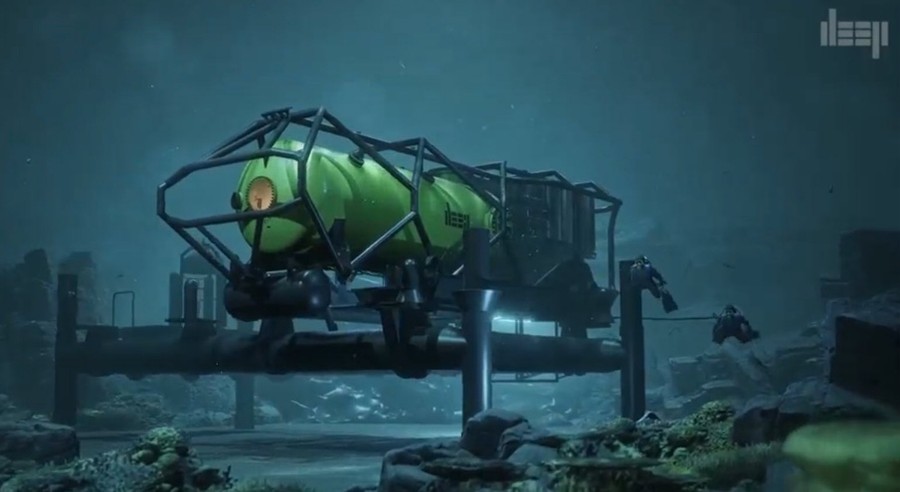
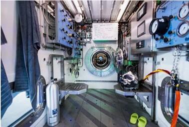
DEEP is working on a problem that has frustrated marine scientists for decades: how do you stay underwater long enough to observe what you came to see? A four-hour dive window, split between descent, work, and ascent, doesn’t give a biologist enough time to watch a spawning event, track a predator’s foraging pattern, or confirm whether a temperature anomaly is a localized artifact or a condition that extends across a wider area. DEEP’s answer is to build habitats rather than vehicles: modular subsea structures rated for sustained occupation at depth, engineered with redundant life-support systems and pressure-tolerant construction, designed to let researchers sleep at depth and wake up still underwater.
The engineering behind this is more demanding than it might appear. Pressure at depth doesn’t compress materials uniformly; it stresses seals, warps tolerances, and creates failure modes that surface-based systems never encounter. Life support in a closed subsea habitat requires monitoring CO2 scrubbing efficiency, oxygen partial pressure, humidity control, and thermal regulation simultaneously, with no margin for drift. DEEP’s work on high-pressure hull design and deployable infrastructure draws on lessons from saturation diving, which has been practiced in offshore oil and gas operations since the 1960s, and adapts those principles for scientific use rather than industrial maintenance. Pictures below are a rendering of DEEP’s state-of-the-art underwater habitat named Vanguard and a photographic (courtesy of DEEP) showing an interior section of Vanguard.
For an early-career oceanographer, the implication worth sitting with is this: if DEEP succeeds in making multi-day subsea habitation routine, it changes what data collection looks like at depth. Continuous behavioral observation of reef species across full diel cycles becomes possible, as does real-time response to storm-driven sediment pulses and long-duration acoustic monitoring without the noise interference that ships introduce. In a large share of current sampling designs, time at depth is the constraint that limits everything else, and DEEP is treating that constraint as an engineering problem rather than an immutable condition.
WHOI: Ninety Years of Going Where the Data Is
WHOI was founded in 1930, two years after a National Academy of Sciences report identified the need for a permanent oceanographic research institution on the U.S. Atlantic coast, and the timing reflected a broader shift in how the scientific community thought about ocean research. The late 1920s saw growing recognition that ocean science required more than occasional survey voyages. It required sustained institutional infrastructure, permanent staff, dedicated vessels, and the capacity to address open questions over years, not months. That founding logic has never changed, even as the tools and questions have.
The deep-submergence vehicle Alvin is probably WHOI’s most recognizable asset. Commissioned in 1964 and repeatedly upgraded since, Alvin holds a rated depth of 6,500 meters following its most recent overhaul, which means it can reach roughly 99 percent of the ocean floor. It was Alvin that carried scientists to the hydrothermal vents along the Galapagos Rift in 1977, a set of dives that produced one of the most consequential surprises in the history of biology: chemosynthetic ecosystems thriving without sunlight, built on sulfur-oxidizing bacteria rather than photosynthesis. Before those dives, the prevailing assumption held that all complex life depended on solar energy as its base, and those dives showed that assumption to be wrong.
Beyond Alvin, WHOI has built a substantial fleet of autonomous underwater vehicles (AUVs) and remotely operated vehicles (ROVs) over the past three decades. The REMUS series of AUVs, originally developed at WHOI, has been adopted by military, commercial, and scientific users worldwide. These vehicles can be programmed to execute pre-planned survey tracks, collecting water column data on temperature, salinity, dissolved oxygen, fluorescence, and acoustic backscatter without a human pilot. For a researcher designing a sampling campaign, that pre-programmed, repeatable transect capability is worth understanding in detail: it doesn’t replace ship-based CTD casts, but it adds spatial resolution at a fraction of the ship time cost.
WHOI’s current work in AI-driven ocean sensing is worth watching. The institution has been developing machine learning tools for processing the large volumes of imagery and sensor data that autonomous platforms collect, a workflow problem that has become a genuine bottleneck. An AUV running an 18-hour mission can return terabytes of sonar imagery. Reviewing it manually at full resolution is not practical. Automated classifiers trained to flag specific features, such as sediment bedforms, benthic fauna assemblages, or acoustic anomalies, are starting to close that gap. The methods are still being validated, but the direction is clear.
GMSO: Making the Data Count Beyond Any One Lab
Ocean science has long struggled with a coordination problem. A research team in Germany deploys a mooring array in the North Atlantic; a team in Japan runs a parallel monitoring program in the North Pacific; a team in Brazil measures coastal upwelling off Cabo Frio. Each group calibrates its instruments by its own standards, names its variables by its own conventions, and archives its data in formats that aren’t always compatible with the others. The science within each program may be entirely sound but combining it to answer questions at basin or global scale requires conversion work that consumes research time and introduces uncertainty that wouldn’t exist if the programs had been coordinated from the start.
GMSO exists, in large part, to address that problem. Its work on standardized oceanographic data protocols builds on frameworks developed through the Argo float program and the Global Ocean Observing System (GOOS), both of which demonstrated that international coordination around data formats produces compounding returns over time. When thousands of Argo floats from dozens of countries report temperature and salinity profiles in the same format to the same archive, the resulting dataset has a scientific value that no single national program could have generated alone. GMSO is working to extend that logic to a broader set of observing systems and research disciplines.
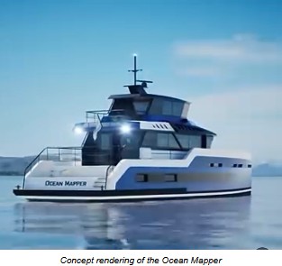
The capacity-building component of GMSO’s work is worth understanding separately. Coastal nations in the Global South hold scientifically valuable and data-sparse ocean territories that are among the least studied on earth. The coral triangle in Southeast Asia, the upwelling zones off West Africa, the shallow carbonate systems of the Caribbean: these regions matter enormously to global biodiversity and climate accounting, and they are systematically under sampled. One of the most significant developments taking shape in 2026 is GMSO’s collaboration with Victor Vescovo (a fellow Texas Chapter member), centered on the design and future operation of next-generation deep ocean mapping vessels. The concept is ambitious: a hyper-efficient, 75-foot (23 m) platform equipped with full-ocean-depth multibeam sonar, capable of mapping nearly 2% of the global seafloor per year with a minimal crew and extended endurance.
GMSO’s approach is to help build local oceanographic capacity, through instrument training, shared vessel access, and co-authorship arrangements, rather than running Northern-hemisphere-led expeditions that extract data without building lasting scientific infrastructure in the host country. The distinction matters, and it’s one that an early-career scientist thinking about international fieldwork should understand before designing a collaboration.
What These Three Entities Are Building Together
The combined picture that DEEP, WHOI, and GMSO present is not one of overlapping mandates. It’s closer to a division of labor that the field has needed for a long time. DEEP is addressing access, the basic constraint of how long and how comfortably a human scientist can work at depth. WHOI is addressing capability, the instrumentation, vehicle systems, and analytical methods that determine what can be measured once you’re down there. GMSO is addressing integration, the governance and coordination structures that determine whether individual measurements accumulate into a scientifically durable record across programs, borders, and decades.
For someone early in an oceanography career, the practical takeaway from watching these institutions is that the field is moving toward longer time series, higher spatial resolution, and broader international coordination. Research designs built around single expeditions or short mooring deployments will increasingly be evaluated against what sustained observing systems can produce. That doesn’t make expedition science obsolete, but it does mean that an early-career researcher who understands how to integrate episodic sampling with continuous observing platforms will be better positioned than one who treats them as separate methods.
There is also a quieter implication in the work of all three organizations, one that doesn’t always make it into grant narratives or press releases. The ocean is changing faster than the observation networks tracking it were designed to detect. Thermal stratification is increasing, oxygen minimum zones are expanding, and coral bleaching events that once occurred on decadal timescales are now happening in consecutive years. The institutions best positioned to contribute to the science that matters in the next twenty years are the ones that have invested in sustained presence, calibrated instrumentation, and the cooperative structures required to aggregate observations into a dataset larger than any single program can produce. DEEP, WHOI, and GMSO are each, in their own way, building toward that.